Content added Content deleted
No edit summary |
No edit summary |
||
| Line 38: | Line 38: | ||
<gallery mode=packed> |
<gallery mode=packed> |
||
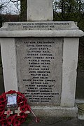
The Stourton and Thwaitegate war memorial - geograph.org.uk - 3882186.jpg|Front panel|alt=A rectangular granite panel with the title "Remember the men of Stourton and Thewaitegate who fell in the great war" above a list of names. |
The Stourton and Thwaitegate war memorial - geograph.org.uk - 3882186.jpg|Front panel|alt=A rectangular granite panel with the title "Remember the men of Stourton and Thewaitegate who fell in the great war" above a list of names. |
||
The Stourton and Thwaitegate war memorial - geograph.org.uk - 3882188.jpg|Left panel |
The Stourton and Thwaitegate war memorial - geograph.org.uk - 3882188.jpg|Left panel|alt=A rectangular granite panel with the title "1914" above a list of names. |
||
The Stourton and Thwaitegate war memorial - geograph.org.uk - 3882187.jpg|Right panel|alt=A rectangular granite panel with the title "1918" above a list of names. |
The Stourton and Thwaitegate war memorial - geograph.org.uk - 3882187.jpg|Right panel|alt=A rectangular granite panel with the title "1918" above a list of names. |
||
The Stourton and Thwaitegate war memorial - geograph.org.uk - 3882184.jpg|Back panel |
The Stourton and Thwaitegate war memorial - geograph.org.uk - 3882184.jpg|Back panel|alt=A rectangular granite panel a list of names and a small back panel attached to it with the title "1939-1945" above more names. |
||
</gallery> |
</gallery> |
||
==Interior== |
==Interior== |
||
Revision as of 14:00, 29 June 2024
The Church of St Andrew was an Anglican church on Pontefract Road in Stourton. The church was consecrated on 23rd July 1898 and was closed around 1973 when the village (along with the rest of the Rothwell Urban District) was transferred to the Leeds Metropolitan Council and the residents of Stourton were displaced to turn it into an industrial area.
History

.jpg)
Exterior
War memorial
-
Front panel
-

Left panel
-

Right panel
-

Back panel


Interior
Notes
References
See also
External links
- The Church of St Andrew on the Church of England website
- Stourton's wall memorial on Roll of Honour